
MEMORIES OF WADDINGTON: A BOY’S JOURNEY THROUGH PROGRESS AND NATURE
By John Yolton
John grew up in Waddington, graduated, and later moved away. He responded to our request to share stories about what life was like before and during the construction of the St. Lawrence Seaway project.
Childhood Explorations in a Former Industrial Town
My journey starts with crawling over the ruins of old factories on the downstream side of the dam that connected to the “island.” The ruins were adjacent to a channel on the mainland, where water had once powered the plants.
I learned about grist mills, paper production, lumber, forging, and printing from my father and from hard-to-find references at the library. This industrial area was accessed from the foot of Main Street, between buildings on St. Lawrence Avenue, along a then-overgrown roadway that had originally been built to provide access to the mills and the waterpower canal.
You had to use your imagination to envision what that scene had once been like.
The community had been an industrial town, but its industries declined because of technological advancements, fires, and cheaper products arriving from other places.
I always wondered, “What would this town have been like if those factories had kept up with emerging technologies such as fire prevention, electricity, and hydraulics?”
A water wheel once turned a line shaft, using pulleys and belts to divert motion and change the speed of rotation. If the spillway had been maintained and the water wheel had been used to generate electricity, someone’s vision of the future might have become a reality.
But it didn’t.
By the time of my childhood, Waddington was a quiet little town—a residential community providing resources to the surrounding centers of business and education, or, in other words, the places that provided jobs.
As a kid exploring the area, I didn’t think about any of that. I simply enjoyed the structures, the wind blowing through the willows and bushes, the water gurgling through the dam, the fish splashing, and the birds singing.
On the island side of the dam and its ruins, time had created a water passageway and a deeper pool below the dam. Fish—especially good-sized redfin mullets—would gather beneath the overgrown trees.
I had a few preteen and early teenage years to explore those ruins. My curiosity was satisfied, and my mom allowed me to roam without knowing exactly what we were doing or who we were with.
We always showed up for dinner.
The Arrival of the Seaway Project
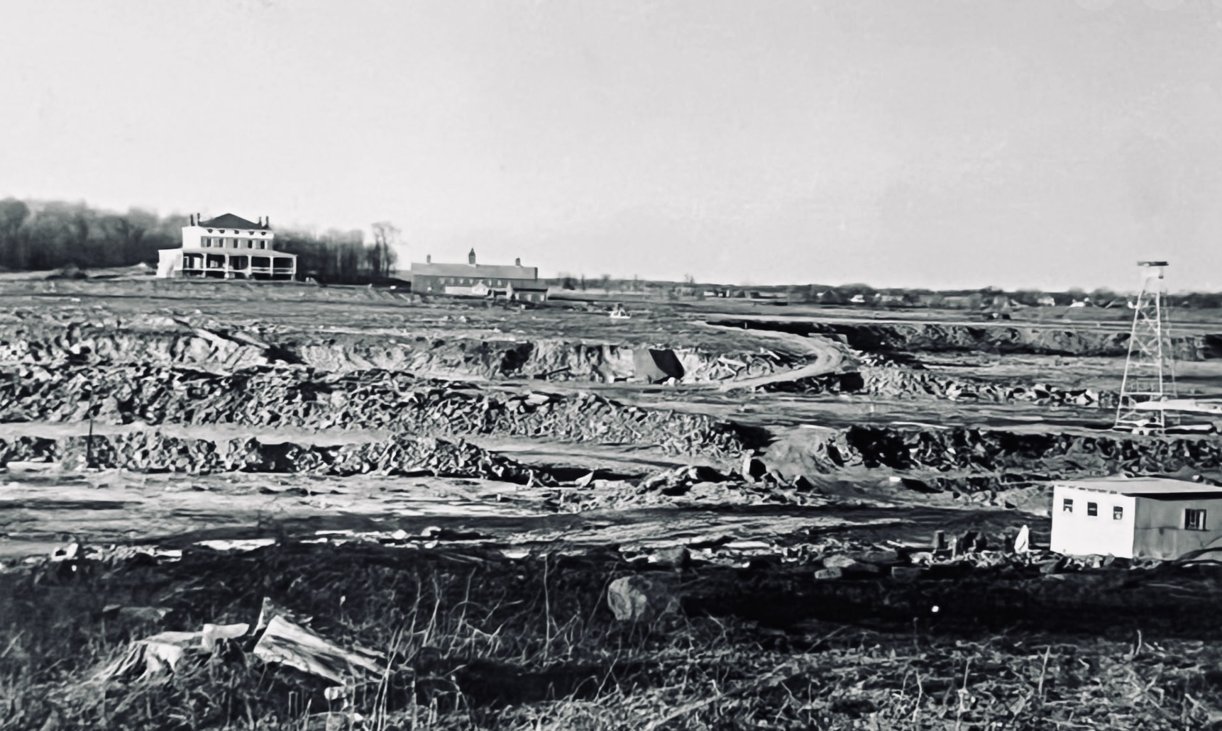
Everything I had explored was eventually removed so the riverbed between the town and the island could be excavated. This ensured that when the river was backed up by the new dams, it would be free of rapids and allow two-way shipping traffic along the Canadian side of the island.
A cofferdam was built at the upstream head of the island to restrict the flow of water on that side. Another was then built downstream, before the outfall of First Creek, officially known as Big Sucker Brook or Brandy Brook.
Between the island and the south shore, the water was pumped out and the debris was removed. It was trucked to a pile at the location where the town beach now stands.
The road was rebuilt from a two-lane country road into a wider gravel highway capable of accommodating the haul vehicles. Dust was controlled by trucks that sprayed water over the road throughout the day and night.
Despite those efforts, dust collected everywhere. It covered the few houses along the new highway, as well as the leaves, trunks, and branches of the roadside vegetation.
The newly improved country road became a bicyclist’s paradise—except for the heavy haul-vehicle traffic and the dust.
A small hill was created from bedrock removed from the deepened channel and reshaped island, as well as from the excavated river bottom between the island and the south shore, an area known as the “Little River.”
Drilling dynamite holes into the bedrock continued day and night. At noon, a whistle alerted the residents of Waddington that a blast was about to occur.
Initially, it was a sight and sound to behold.
Before each explosion, a heavy blanket of rope woven with rubber strips was dragged over the blast site to minimize flying debris. It was surface-mining technology at its best for the time.
Eventually, however, it became just another routine. People began complaining about the noise of the daily explosions and the vibrations that caused cracks in their walls, rather than marveling at the technological progress.
A huge dragline called the “Gentleman” and a smaller one called the “Lady” were stationed on the island for the summer. A pickup truck could easily fit inside the bucket of the larger dragline.
These two massive excavators were like a village unto themselves, with crews of operators, mechanics, and lubricators constantly working to keep them running around the clock.
Once transported to the island by barge, the draglines were capable of “walking” to the locations where they were needed. They scooped enormous quantities of dirt and rock from a surveyed path, removing large portions of the island so the widened river could pass around its newly reshaped shoreline.
I was deeply impressed by this technology.
I constructed a miniature dragline using slats from discarded produce-shipping boxes. I equipped it with thread spools for “cables,” using twine, and built a swiveling platform that I could sit on while swinging the boom.
The bucket was made from a Campbell’s soup can, with teeth shaped using tin snips.
I spent hours behind our house on Oak Street moving buckets of soil within the reach of the boom, mimicking the construction workers on the island.
I was literally learning the ropes.
It was a good education—and a lesson in progress.
On the island, smaller shovels filled the haul vehicles from the piles deposited by the draglines. The vehicles then crossed the empty basin to the town and traveled up the road to the growing riverside hill upstream.
On the mainland, workers were constructing a new bridge across Big Sucker Brook, which we called “First Creek.” They were also digging a canal between Little Sucker Brook, our “Second Creek,” and Big Sucker Brook—officially known as Little Brandy and Brandy creeks.
Old Route 37 was diverted from St. Lawrence Avenue to Lincoln Avenue. On the west end of town, the highway was rerouted at Maple Street onto a straighter path that connected with the old Route 37 just east of Ogdensburg.
Bypasses were also built around Massena and Ogdensburg.
Life in a Transforming Community
We lived at the corner of Lincoln Avenue and Oak Street, directly across from St. Mary’s Catholic Church. The church’s side yard served as a playground for the neighborhood children, including the Whitfords, Barkleys, Mayettes, Hendersons, Donies, Tiernans, and others.
“Hide-and-Seek” and “Prison” were popular games among us.
In “Prison,” one child would walk around the perimeter of the lawn carrying a flashlight, while the others tried to avoid being caught in the beam. Anyone caught in the light was removed from the game. The objective was to reach the opposite side of the lawn without being spotted.
The Seaway project required Lincoln Avenue to be extended east toward Massena, beyond Oak Street, where it had previously ended. The extension passed through empty fields behind the Barkleys’ house, crossed the new bridge, and continued along a newly constructed highway past Coles Creek.
The fields behind the Barkleys’ home on Oak Street and the Hollyhock Inn on St. Lawrence Avenue rose uphill toward a knoll. They then sloped downward toward First Creek as it curved around the hill, heading west and south before intersecting with Franklin Road near Chamberlin’s Corners.
The entire hill was covered with pastureland and scrub brush. Property lines could be identified by piles of stones that had accumulated along the edges through years of picking, dragging, and tossing rocks from the fields.
As the farmers used to say, there was “one crop you could always depend upon—the annual appearance of stones” following every winter.
Our treks through the pastureland down to First Creek to catch bullheads, perch, and eels were accompanied by fires burning along the shoreline. Coleman gas lanterns lit the darkness, while bamboo fishing poles stood ready with bobbers that plunged beneath the water whenever a fish took the bait.
The fish we caught were placed on stringers or in pails. The stringers were anchored to the streambank, while the pails were filled about one-quarter of the way with creek water.
Every spring, we purchased our fishing supplies from Hanes & Hansons.
I spent many days wandering through those fields, daydreaming about adventures and surveying the town and the Canadian shoreline, which was visible miles away across the river.
On a warm spring day, it was a wonderful place to lie on the winter-flattened grass beside the melting snowpack, watch the clouds pass overhead, and bask in the sunlight.
Critters were everywhere. Groundhogs emerged from hibernation, chipmunks scurried through the stone piles, and the occasional garter snake slithered through the warming grass.
In spring, First Creek became a torrent, draining the upper pastures. During the summer, after the runoff had subsided, it was fed by upstream springs and pools scattered along its meandering shoreline.
Dairy cattle populated the pastureland, creating trails—or cow paths—as they moved along the creek. The trails were interrupted only by fences.
Following those paths and jumping fences onto other people’s property was a delight.
You had to watch where you stepped, however. The pastures were well fertilized with organic material—some of it fresh and some of it not.
We often hiked along the shores of First Creek toward Buck Road, picking leeks and toppling old, dead trees in the woodlots. We usually ate more than we collected. The same was true of the wild raspberries and blackberries that ripened during the summer.
Where Franklin Road veered to the left, an unpaved extension of Oak Street continued straight up the hill. Nearby was a spring-fed swamp, overgrown with willow bushes, where the water froze during winter and created a natural skating area.
Continuing up the lane led to an old, collapsed farmhouse that had originally stood on the same hill as the village water tank.
The fields surrounding the old home were used as pastureland, and the hay was harvested each year. The lane continued downhill to the south, eventually connecting with Linden Street.
Linden Street followed First Creek, with the town cemeteries situated between the creek and the road.
To the north, Oak Street ended at St. Lawrence Avenue, the village’s main thoroughfare and a busy street that ran parallel to the river. Beyond it, an unpaved lane extended down to the water at Black’s Landing.
There were shacks, one residence, and river-level docks with unattended rowboats and wooden cages containing sturgeon that were being held for market.
Buck Road was also home to the town and village dump.
Because there were no garbage-collection services, we took our trash there every week or two. This was before plastic became common. Old newspapers, glass containers, and metal containers were often reused, so there was far less trash than there is today.
The open dump, however, was a haven for rats. It provided easy hunting for anyone with a .22 rifle and enough change to buy a box of shells.
The local fish and game club held an annual varmint contest each spring. Tails from rats, groundhogs, muskrats, squirrels, blackbirds, and crows were counted toward the total prize money.
Before the Seaway project, traveling east required heading downhill to St. Lawrence Avenue, then Route 37, to cross the bridge over First Creek.
On that side of the creek, there were sand dunes between the railroad tracks and the water. We had many imaginative adventures in and around those dunes.
Farther along the old road to Massena, on the river side, stood the Doelger property. It was located high above the riverbank, just downstream from the pulp docks and before the bridge over Second Creek.
The entire area was submerged after the Seaway was completed.
This was heady stuff for a preteen and teenager growing up in a quiet farming town beside a river.
St. Lawrence County was often in contention for the title of the largest dairy-producing county in the United States, competing with Marathon County in Wisconsin.
We had a private telephone connection in our house, but many families did not. Each household on a party line had its own ring code, allowing people to know whether an incoming call was intended for them or for one of their neighbors.
People often listened in on other families’ conversations.
Imagine if that were still the case today.
One frequent event during my idyllic childhood was the potluck dinner held in the basement of the town library. The basement had a kitchen and plenty of seating.
Some people came to collect samples from the various “pots,” filling a plate and taking it home or somewhere else to eat. It was much like the cafeteria-style restaurants found in towns and cities today.
The volunteer fire department was the largest “professional” organization in town. Whenever a young man reached a certain age, he would submit an application to become a volunteer firefighter.
That tradition continued for many years.
Going downtown to Main Street was a daily occurrence. Families went there to buy groceries from the two—and later three—stores located along the street: Heverly’s, Campbell’s, and, later, Short’s across the road.
Changes to the Landscape
The movie theater was a special treat for local children, but it closed during the Seaway project.
Slim and Louise DeFazio later opened a restaurant and bar inside the former theater building, across Main Street from the St. Lawrence Hotel.
When the new Route 37 opened along Lincoln Avenue, running east toward Massena and west toward Ogdensburg, Slim and Louise opened the Towne House at the corner of Oak Street and Lincoln Avenue.
They and their restaurant became an important part of the town’s post-Seaway history.
The previously empty land east of Oak Street and Franklin Road—mostly pastureland divided by rock-strewn fence rows—began filling with homes and businesses along the new highway.
Funding from the Seaway project also provided a recreational area with tennis courts, a baseball field, and a park for the children.
Almost overnight, tennis became a regular pastime for local kids. Sandlot baseball games became more organized and were played on a regulation field.
Most importantly, although it is often overlooked, the village’s sewage-treatment plant and collection system were installed during the Seaway project.
Life before the project was not quite like The Adventures of Tom Sawyer or Adventures of Huckleberry Finn, but it was very similar.
The experience had a significant effect on the course of my life.
In later years, I often reflected on the changes that took place in that small town.
What would the future bring?
I had no idea, nor could I have anticipated what would follow.
Progress is inevitable, and what you make of it determines what lies ahead.
Those days were absolute bliss for me, and I still have fond memories of them today.